This is an old revision of the document!
Table of Contents
Coordinates
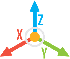
In Questies, Coordinates define the location of characters, Points, and Areas in the World. Coordinates use a three-axis system: X, Y, and Z, allowing for precise placement in a three-dimensional space.
How Coordinates Work
- X-Axis: Represents east-west movement.
- Positive X (+X): Moves east.
- Negative X (-X): Moves west.
- Y-Axis: Represents north-south movement.
- Positive Y (+Y): Moves north.
- Negative Y (-Y): Moves south.
- Z-Axis: Represents vertical movement.
- Positive Z (+Z): Moves upward.
- Negative Z (-Z): Moves downward.
Each unit on the coordinate grid corresponds to 1 decameter (10 meters, 11 yards or 33 feet) in the World. This allows for precise scaling and makes distances intuitive to calculate.
World Boundaries
A World spans a massive coordinate grid with the following limits:
- X: From -100,000 to +100,000.
- Y: From -100,000 to +100,000.
This means the World is 200,000 units across, which translates to 2,000,000 meters (2,000 kilometers) or approximately 1,240 miles from one edge to the other.
Gameplay Implications
- Exact Placement: All Points, Areas, and characters are tied to specific (X, Y, Z) coordinates. This precision ensures clear navigation and interaction with the World.
- World Design: The large boundaries provide space for diverse environments, from sprawling kingdoms to dense forests or towering mountains.
- Scale Awareness: Knowing that each unit equals 10 meters helps players and World creators visualize distances and sizes accurately.
Vertical Integration with Z-Levels
Coordinates integrate seamlessly with Z-Levels, which represent vertical layers of the World. While X and Y define horizontal placement, Z defines height or depth. Movement between Z-Levels requires a Point transition, such as stairs, ladders, or cave entrances, ensuring logical traversal across layers.